Landscape & visual impact assessment (LVIA)
A Landscape and Visual Impact Assessment helps identify and mitigate the effects of new developments on both the landscape of the site and the wider setting and also on the ‘visual receptors’, i.e., the people who will experience the landscape, e.g., residents, visitors, walkers and drivers, etc.
LVIA can be required for a wide range of development projects. Generally, but not solely restricted to the larger types of development, including: renewable energy schemes, residential and commercial development, but can also be required for smaller projects, e.g., a single dwelling, where these are located within a particularly sensitive and often highly designated landscape such as Areas of Outstanding Natural Beauty (AONB), World Heritage Site (WHS) or close to important heritage or ecological assets, e.g., Scheduled Monuments and Special Areas of Conservation (SAC), etc.
To be of greatest value to the design development, LVIA should commence at the earliest opportunity in the project development, as this process will help inform the design and any potential mitigation required, (this may initially commence as an LVA) but it can also highlight potential impacts on landscape and visual receptors which could be designed out or reduced at an earlier stage of the design process – saving unnecessary expense and time later in the process and giving the best chances of a positive planning outcome. We can advise on and prepare mitigation plans as required.
LVIA’s are tailored according to the scale and nature of the proposed development, but they all follow the same structure and methodology based on the Guidelines for Landscape and visual Impact Assessment 3rd Edition (GLVIA3) prepared by the Landscape Institute and the Institute of Environmental Management and Assessment.
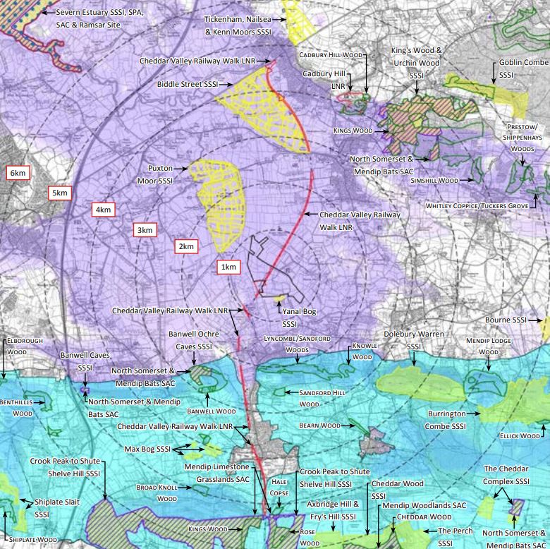
The process involves a combination of desk study and a detailed site visit to assess the site character and the character and visibility of the site from the surrounding landscape setting. Viewpoint locations are based on the production of a Zone of Theoretical Visibility (ZTV) plan, which highlights potential areas from where the site would be visible. This leads to the preparation of the baseline data, identifying the key landscape and visual receptors. The impact assessment process can then be undertaken when the design is sufficiently developed.
Extensive graphic Appendices are prepared as part of the LVIA, which include the ZTV and plans of all the statutory and non-statutory landscape, heritage and ecological designations and public access plans. Landscape Character Area / Type Plans, and a range of site photographs and annotated viewpoint photographs of the site from the key viewpoints.
Cumulative Landscape & Visual Impact Assessment (CLVIA)
This is an extension to the LVIA process where there can be a requirement to assess the impacts of a development alongside the impacts of other similar developments within the area to determine if jointly, they create a substantial change to the landscape character of the area and/or substantial alter the visual experience of the landscape.